About
This project is a modular, node-based computational environment developed within Blender using Sverchok. It integrates data gathering, spatial analysis, generative modelling, and interactive visualisation into a single coherent workflow.
The system was developed as part of a doctoral research project focused on computational tool development for data-driven urban design.
The broader conceptual and technical development can be accessed here:
Computational Development Chapter
Conceptual Framework
The architecture is structured around a layered computational framework that organises how data, tools, and design processes interact.
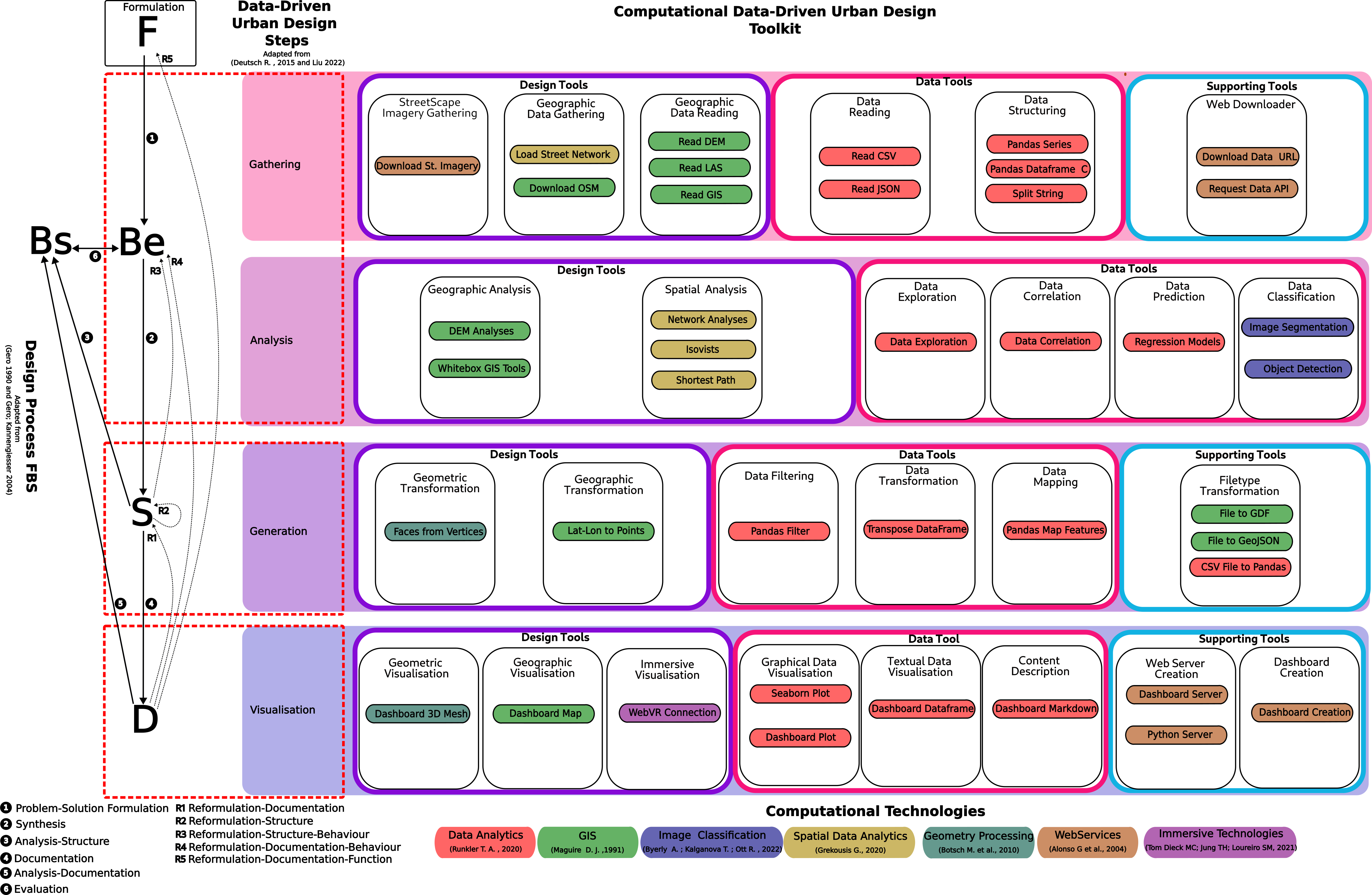
It establishes a structured relationship between:
- Contextual data
- Computational toolkit
- Generative systems
- Visualisation and deployment
Rather than a linear workflow, the framework supports modular recombination and iterative loops.
Node Architecture
The node system reflects this framework and is organised into four primary domains:
- Gathering — contextual and structured data integration
- Analysing — metric computation and quantitative evaluation
- Generating — parametric transformation and geometry construction
- Visualising — interactive representation and deployment
Each domain corresponds to a distinct computational responsibility while remaining interoperable within the same node tree.
The structure aligns with Sverchok’s evaluation model, where nodes execute when linked, pass structured outputs downstream, and maintain explicit data typing:
Sverchok Tree Evaluation System
Scope
The environment supports:
- GIS vector and raster integration
- LiDAR and terrain processing
- Street network analysis
- Statistical and machine learning workflows
- Parametric geometry generation
- Dashboard creation and web deployment
- Interactive map-based visualisation
- VR-ready exports
It bridges computational design, spatial data science, and interactive communication inside a unified node-based ecosystem.
Development Context
The system was developed during doctoral research and evolved through iterative experimentation, tool refinement, and integration of open-source computational technologies.
Its structure reflects a synthesis of:
- GIS and spatial analytics
- Network science
- Data science workflows
- Parametric modelling
- Interactive dashboard systems
The result is a coherent computational architecture where contextual data, analytical methods, generative systems, and communicative outputs operate as distinct yet interconnected components.